


၏ ရွင္းလင္းခ်က္ World atlas & world map MxGeo
World atlas, world map and educational app for geography. Flags, position maps and basic data for more than 240 countries and territories of the world. Political maps with regional units and comprehensive economic and statistical country data for all African countries.
Designed for smartphones and tablets.
• Flags, position maps and basic data for more than 240 countries of the world
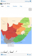
• Political maps and comprehensive data of all African countries
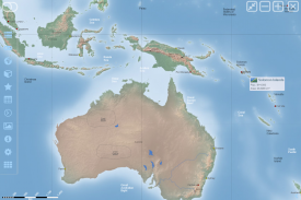
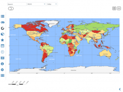
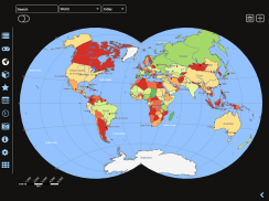
• Interactive political world and continent maps
• Shaded relief layer for world and continent maps
• Geography quiz challenge for playful learning
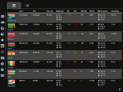
• Country comparison, favorites and distance calculator
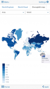
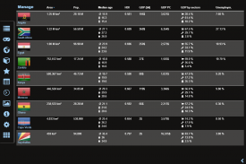
• Choropleth maps: area and population
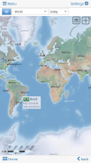
• Configurable world clock with time zone display
• World-explorer: the smallest, largest, ... countries
• No online connection required
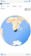
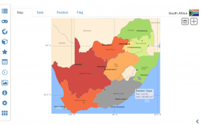
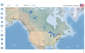
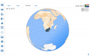
Explore the world by political world and continent maps offline maps. Learn where each country in the world is located. View its position highlighted on a digital globe. Create your favorite color theme or choose from different color schemes for map display.
Do you know the flag of Zambia? Yes? Perfect. Do you also know in which country Mount Kilimanjaro is located? “World atlas & world map MxGeo Free” Quiz helps you acquire a geographic literacy in a playful manner.
Choose from six geo guessing games:
• Test your knowledge about the capitals of Africa
• Do you know the ISO countries codes?
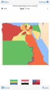
• Recognize the proper country flag based on the outline map
• Do you know the top-level domains of each country?
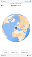
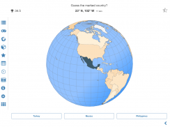
• Guess the highlighted country on the virtual globe
• Do you know the mountains of Africa?
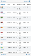
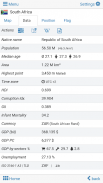
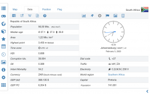
Geo learning app and educational game which is fun for everyone whether children, adults, seniors or teachers. Get ready for your next stay abroad while enjoying this great world almanac including time zones and statistical data, such as population growth, unemployment rate, average age, gross domestic product (GDP) by sector and other key figures. Or prepare for your next geography lesson with this genius digital world map. If not traveling our world atlas lets you explore the world just only virtually.
Free version includes comprehensive data and maps for all African countries. Get “World atlas & world map MxGeo Pro” with detailed data and maps including regional units and capitals for 240 countries and territories of the world: Europe, Asia, North America, Africa, Oceania and South America.
Version history:
Ver. 1.x:
• world map, country maps and flags
• capitals, country flag and virtual globe quiz
• world-explorer: explore the smallest, largest and most populated countries
• country comparison: quick comparison of countries and territories
• favorites: shortcut your favorite countries
• corrections and updates of country data and maps
Ver. 2.x:
• high resolution flags for all countries
• population growth chart for all countries
• no app permissions
• continent maps of Asia, Europe, South and North America and Oceania
• improved country comparison, with sorting function
• Full-screen mode for Android >4.4
• additional Geo Quiz: mountains of the world
• corrections and updates of country data and maps
Ver. 3.x:
• shaded relief layer for world and continent maps
• interactive rotating virtual globe
• performance optimization for map view
• optional high quality mode for virtual globe
• world clock: time zones map optimized
• corrections and updates of country data and maps
Ver. 4.x:
• countries maps update: now including neighbor countries and more details
• additional regional position maps incl. marine region info
• time series charts for gross domestic product (GDP) and unemployment rate added
• distances and areas can now be displayed in kilometers or miles
• info about voltage and plug types added
• adjustable font size for map labels
• choropleth maps by area and population
• world-explorer: new key figure average temperature
• corrections and updates of country data and maps
ကမ္ဘာ့ဖလား Atlas, ပထဝီများအတွက်ကမ္ဘာ့မြေပုံနှင့်ပညာရေး app ကို။ ကမ္ဘာ၏ထက်ပိုမို 240 နိုင်ငံများနှင့်နယ်မြေများများအတွက်အလံ, အနေအထားကိုမြေပုံနှင့်အခြေခံဒေတာ။ ဒေသဆိုင်ရာယူနစ်အပေါင်းတို့နှင့်အာဖရိကနိုင်ငံများအတွက်ပြီးပြည့်စုံသောစီးပွားရေးနှင့်စာရင်းအင်းတိုင်းပြည်ဒေတာနှင့်အတူနိုင်ငံရေးပါတီများမြေပုံ။
စမတ်ဖုန်းများနှင့် tablet များအတွက်ရည်ရွယ်ထုတ်လုပ်ထားတာ။
•ကမ္ဘာ၏ထက်ပိုမို 240 နိုင်ငံအလံများ, အနေအထားကိုမြေပုံနှင့်အခြေခံဒေတာ
•နိုင်ငံရေးမြေပုံများနှင့်အားလုံးအာဖရိကနိုင်ငံများတွင်ပြည့်စုံဒေတာ
• Interactive မှကမ္ဘာ့နိုင်ငံရေးလောကနှင့်တိုက်ကြီးမြေပုံ
ကမ္ဘာနှင့်အာဖရိကတိုက်မြေပုံများအတွက်• Shaded ကယ်ဆယ်ရေးအလွှာ
အပျော်အပျက်သင်ယူမှုများအတွက်•ပထဝီပဟေဠိစိန်ခေါ်မှု
•နိုင်ငံနှင့်နှိုင်းယှဉ်လျှင်အကြိုက်ဆုံးများနှင့်အကွာအဝေးဂဏန်းတွက်စက်
• Choropleth မြေပုံ: ဧရိယာနှင့်လူဦးရေ
အချိန်ဇုန် display နဲ့အတူ Configuration ကမ္ဘာကြီးနာရီ•
•ကမ္ဘာ့ဖလား-ရှာဖွေသူ: အသေးဆုံး, အကြီးဆုံး, ... နိုင်ငံအများ
•အဘယ်သူမျှမအွန်လိုင်းဆက်သွယ်မှုလိုအပ်
ကမ္ဘာ့နိုင်ငံရေးလောကအားဖြင့်လောကဓာတ် Explore နှင့်တိုက်ကြီးအော့ဖ်လိုင်းမြေပုံများမြေပုံ။ ကမ်ဘာပျေါတှငျတစျခုစီတိုင်းပြည်တည်ရှိရာလေ့လာပါ။ ၎င်း၏အနေအထားကိုဒစ်ဂျစ်တယ်ကမ္ဘာလုံးအပေါ်မီးမောင်းထိုးပြကြည့်ရှုပါ။ သင်အကြိုက်ဆုံးအရောင်ဆောင်ပုဒ် Create သို့မဟုတ်မြေပုံ display ကိုများအတွက်ကွဲပြားခြားနားသောအရောင်အစီအစဉ်များကနေရွေးချယ်ပါ။
သငျသညျဇမ်ဘီယာ၏အလံကိုသိသလား? ဟုတ်ကဲ့? စုံလင်သော။ သင်သည်လည်းတောင်ပေါ်က Kilimanjaro တည်ရှိပြီးသောတိုင်းပြည်အတွင်းသိသလား "ကမ္ဘာ့ဖလား Atlas & ကမ္ဘာ့မြေပုံ MxGeo အခမဲ့" ပဟေဠိသင်တစ်ဦးပျြောထုံးစံ၌တစ်ပထဝီစာတတ်မြောက်ရေးဆည်းပူးကူညီပေးသည်။
ခြောက်လပထဝီခန့်မှန်းဂိမ်းများကိုမှရွေးပါ:
•အာဖရိက၏မြို့တော်အကြောင်းကိုသင့်ရဲ့အသိပညာစုံစမ်း
•သင်က ISO နိုင်ငံများတွင် codes တွေကိုသိသလား
•အအကြမ်းဖျင်းမြေပုံပေါ်တွင် အခြေခံ. သင့်လျော်သောတိုင်းပြည်အလံအသိအမှတ်ပြု
•သင်အသီးအသီးမိမိတို့နိုင်ငံ၏ထိပ်တန်း-level domain ကိုသိသလား?
•က virtual ကမ္ဘာလုံးပေါ်တွင်မီးမောင်းထိုးပြတိုင်းပြည်ဖြစ်မယ်ထင်ပါလဲ
•သင်အာဖရိက၏တောင်သိကြပါသလား?
ပထဝီ app ကိုလူတိုင်းရှိမရှိကလေးများ, အရွယ်ရောက်အကြီးတန်းသို့မဟုတ်ဆရာ, ဆရာမများအတွက်ပျော်စရာဖြစ်သည့်ပညာရေးဆိုင်ရာဂိမ်းသင်ယူခြင်း။ အချိန်ဇုန်နှင့်စာရင်းအင်းဆိုင်ရာအချက်အလက်များ, ထိုကဲ့သို့သောလူဦးရေကြီးထွားမှု, အလုပ်လက်မဲ့နှုန်းသည်ပျမ်းမျှအသက်, စုစုပေါင်းပြည်တွင်းထုတ်ကုန် (ဂျီဒီပီ) အဖြစ်ကဏ္ဍကနှင့်အခြားသော့ချက်ကိန်းဂဏန်းများအပါအဝင်ဤကွီးစှာသောကမ္ဘာကြီးကို almanac ခံစားနေချိန်မှာပြည်ပမှာသင်၏နောက်နေထိုင်ဘို့အဆင်သင့်ရယူပါ။ သို့မဟုတ်ဤပါရမီဒစ်ဂျစ်တယ်ကမ္ဘာ့မြေပုံနှင့်အတူသင်၏နောက်ပထဝီသင်ခန်းစာဘို့ပြင်ဆင်လော့။ ကျွန်တော်တို့ရဲ့ကမ္ဘာကြီး Atlas ခရီးသွားလာမဟုတ်ခဲ့လျှင်သင်ရုံသာနီးပါးကမ္ဘာကြီးကိုစူးစမ်းပေးနိုင်ပါတယ်။
အခမဲ့ဗားရှင်းအားလုံးအာဖရိကနိုင်ငံများအတွက်ပြီးပြည့်စုံသောအချက်အလက်များနှင့်မြေပုံပါဝင်သည်။ ဥရောပ, အာရှ, မြောက်အမေရိက, အာဖရိက, Oceania နှင့်တောင်အမေရိက: ကမ္ဘာ၏ 240 နိုင်ငံများနှင့်နယ်မြေများများအတွက်ဒေသဆိုင်ရာယူနစ်နှင့်မြို့တော်အပါအဝင်အသေးစိတ်အချက်အလက်များနှင့်မြေပုံနှင့်အတူ "Pro ကိုကမ္ဘာ့ဖလား Atlas & ကမ္ဘာ့မြေပုံ MxGeo" ကိုရယူပါ။
ဗားရှင်းသမိုင်း:
Ver ။ 1.x:
•ကမ္ဘာ့မြေပုံ, နိုင်ငံမြေပုံများနှင့်အလံ
•မြို့တော်, နိုင်ငံအလံနှင့်ကို virtual ကမ္ဘာလုံးပဟေဠိ
•ကမ္ဘာ့ရှာဖွေသူ: အသေးဆုံး, အကြီးဆုံးနှင့်လူဦးရေအများဆုံးနိုင်ငံများစူးစမ်း
•တိုင်းပြည်နှိုင်းယှဉ်: နိုင်ငံများနှင့်နယ်မြေများ၏လျင်မြန်နှိုင်းယှဉ်
•အကြိုက်ဆုံး: သင်၏အကြိုက်ဆုံးနိုင်ငံများတွင်ဖြတ်လမ်း
•တိုင်းပြည် data နဲ့မြေပုံ၏ပြင်ဆင်ချက်များနှင့်မွမ်းမံမှုများ
Ver ။ 2.x:
နိုင်ငံအားလုံးအတှကျ•အမြင့်ဆုံး resolution ကအလံ
နိုင်ငံအားလုံးအတှကျ•လူဦးရေတိုးတက်မှုနှုန်းဇယား
•အဘယ်သူမျှမ app ကိုခွင့်ပြုချက်
•အာရှ, ဥရောပ, တောင်အာရှနှင့်မြောက်အမေရိကနှင့်သမုဒ္ဒရာဒေသ၏တိုက်ကြီးမြေပုံ
sorting function ကိုအတူ•တိုးတက်လာသောနိုင်ငံကနှိုင်းယှဉ်,
အန်းဒရွိုက်> 4.4 များအတွက်•အပြည့်အဝမျက်နှာပြင် mode ကို
•အပိုဆောင်း Geo ပဟေဠိ: ကမ္ဘာ၏တောင်များ
•တိုင်းပြည် data နဲ့မြေပုံ၏ပြင်ဆင်ချက်များနှင့်မွမ်းမံမှုများ
Ver ။ 3.x:
ကမ္ဘာနှင့်အာဖရိကတိုက်မြေပုံများအတွက်• shaded ကယ်ဆယ်ရေးအလွှာ
•အပြန်အလှန်လှည့်ကို virtual ကမ္ဘာလုံး
မြေပုံမြင်ကွင်းများအတွက်•စွမ်းဆောင်ရည် optimization
•ကို virtual ကမ္ဘာလုံးများအတွက် optional ကိုအရည်အသွေးမြင့်မား mode ကို
•ကမ္ဘာကြီးနာရီ: အချိန်ဇုန် optimized MAP
•တိုင်းပြည် data နဲ့မြေပုံ၏ပြင်ဆင်ချက်များနှင့်မွမ်းမံမှုများ
Ver ။ 4.x:
•နိုင်ငံများတွင်မြေပုံများအားမွမ်းမံခြင်း: ယခုအိမ်နီးချင်းနိုင်ငံများနှင့်အသေးစိတ်အပါအဝင်
•အပိုဆောင်းဒေသဆိုင်ရာအနေအထားမျိုးကွဲများအပါအဝင်မြေပုံ။ အဏ္ဏဝါဒေသအချက်အလက်
•စုစုပေါင်းပြည်တွင်းထုတ်ကုန် (ဂျီဒီပီ) အတွက်အချိန်စီးရီးဇယားများနှင့်အလုပ်လက်မဲ့နှုန်းကဆက်ပြောသည်
•အကွာအဝေးနှင့်ဒေသများယခုကီလိုမီတာသို့မဟုတ်မိုင်တွင်ပြသနိုင်ပါသည်
•ဗို့အားနှင့် plug ကိုအမျိုးအစားများအကြောင်းကိုအချက်အလက်ကဆက်ပြောသည်
မြေပုံတံဆိပ်များများအတွက်•ချိန်ညှိစာလုံးအရွယ်အစား
ဧရိယာနှင့်လူဦးရေအားဖြင့်• choropleth မြေပုံ
•ကမ္ဘာ့ရှာဖွေသူ: အသစ်က key ကိုကိန်းဂဏန်း၏ပျမ်းမျှအပူချိန်
•တိုင်းပြည် data နဲ့မြေပုံ၏ပြင်ဆင်ချက်များနှင့်မွမ်းမံမှုများ
World atlas & world map MxGeo - ဗားရွင္း 9.1.2
(09-01-2024)
World atlas & world map MxGeo - APK သတင္းအခ်က္အလက္
APK ဗားရွင္း: 9.1.2package: de.mediaz.mxapp.hpbgeodefreeက႑တူအက္ပ္မ်ား
သင္ႏွစ္သက္ႏိုင္သည္မ်ားမွာ...


